If you're an old school real estate agent, appraiser, heck, anyone who used to do a lot of driving before smart phones, you are familiar with the Thomas Guide maps. The Thomas Guide was started by cartographer George Coupland Thomas and his two brothers in 1915 to help travelers find their way around growing and frequently changing cities in the United States.
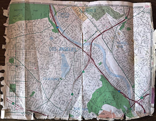
The Thomas Brothers developed a page and grid number system which they published in their yearly street guides. The page and grid layout is a national based tiling system. Map grids are 1/2 mile square, and are numbered from Grid A1 through Grid J7. The letters A to J are along the top of the map left to right and represent the columns. The numbers are on the sides of the map top to bottom and represent the rows. Below is a photo of one well used map page as an example.
The idea of the map grid system probably came from the US Government Survey System from the National Atlas. This is based on the Public Land Survey System (PLSS) which is the surveying method developed and used in the United States to plat, or divide, real property for sale and settling. It uses a similar system based on townships and sections though with a slightly different section numbering system than Thomas Brothers maps.
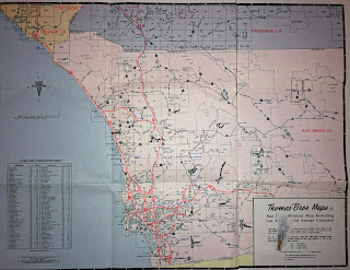
Below is a copy of the 1991 "Los Angeles, Orange and San Diego County Foldout Map" which I bought along with a spiral bound map book with laminated pages.* It's the index, key, guide for the map book. It includes parts of Ventura and San Bernardino Counties. I also included the other side of that map which has the rest of Orange County, San Diego County, Riverside County. The green squares with numbers in them represent detail maps in the Guide.
If you're looking for Thomas Guide Los Angeles, California map page and grid numbers for a specific address in the city of Los Angeles (city only and not the entire county of Los Angeles), input the address in the below links. Use Zimas first because it's quicker and easier.
Zimas http://161.149.40.71/ Click "Address/Legal" top left. Scroll down a little top left and you'll see "Thomas Brothers Grid."
You can also use Los Angeles City Building and Safety http://www.ladbs.org if Zimas is down. The direct page link https://www.ladbsservices2.lacity.org/OnlineServices/?service=plr Enter address then click on Parcel Profile Report for the address. Click the address which should be blue and underlined. Scroll down until you see Thomas Brothers Map Grid. The page and grid number is directly to the right.
*Disclaimer: I'm sharing these old parts of paper maps under the Fair Use of Copyright under the Copyright Act to talk about the old mapping system and its history in Los Angeles, California. This is a 1991 map which is totally out of date and not useful as a map especially in the digital age of smart phones which have free maps with GPS. There are copies of Thomas Guide maps for Los Angeles County, California in the Library of Congress which are copyright free. This map is the same age. While Thomas Brothers own the copyright to printed maps they do not own the actual maps, map numbering system or the map page and grid numbers.
Wall size glass framed Thomas Guide map of Los Angeles county in an old LA Fire Dept museum near Olvera Street. It's about 6-7 feet tall.
Mary Cummins of Cummins Real Estate is a certified residential licensed appraiser in Los Angeles, California. Mary Cummins is licensed by the California Bureau of Real Estate appraisers and has over 35 years of experience.
- Mary Cummins LinkedIn
- Mary Cummins Meet up
- Cummins Real Estate on Facebook
- Mary Cummins Real Estate blog
- Cummins Real Estate on Google maps
- Mary Cummins of Animal Advocates
- Mary Cummins biography resume short
- Mary Cummins Real Estate Services
- Animal Advocates fan page at Facebook.com
- Mary Cummins
- Mary Cummins Animal Advocates on Flickr photos
- Mary Cummins Animal Advocates on Twitter.com
- Mary Cummins on MySpace.com
- Mary Cummins on YouTube.com videos
- Mary Cummins of Animal Advocates on Classmates
- Mary Cummins on VK


